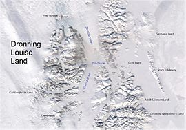
Native name: Nunat Dronning Margrethe II | |
|---|---|
 Queen Margrethe II Land in the southeast | |
| Geography | |
| Location | East Greenland |
| Coordinates | 75°40′N 21°0′W / 75.667°N 21.000°W |
| Adjacent to | |
| Length | 112 km (69.6 mi) |
| Width | 65 km (40.4 mi) |
| Highest elevation | 1,756 m (5761 ft) |
| Administration | |
Greenland (Denmark) | |
| Zone | NE Greenland National Park |
| Demographics | |
| Population | Uninhabited |
| Official name | Hochstetter Forland |
| Designated | 27 January 1988 |
| Reference no. | 390[1] |
Queen Margrethe II Land (Danish: Dronning Margrethe II Land) is a peninsula in the northern limit of King Christian X Land, northeastern Greenland.[2] Administratively it belongs to the NE Greenland National Park area.
- ^ "Hochstetter Forland". Ramsar Sites Information Service. Retrieved 25 April 2018.
- ^ "Catalogue of place names in northern East Greenland". Geological Survey of Denmark. Retrieved 1 July 2016.
