Quesada | |
|---|---|
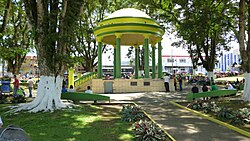
 Central park of Ciudad Quesada | |
 Quesada district | |
| Coordinates: 10°20′39″N 84°25′12″W / 10.3440686°N 84.4198985°W | |
| Country | |
| Province | Alajuela |
| Canton | San Carlos |
| Government | |
| • Syndic | Adolfo Enrique Vargas Aragonés (CUSC) |
| Area | |
| • Total | 144 km2 (56 sq mi) |
| Elevation | 656 m (2,152 ft) |
| Population (2011) | |
| • Total | 42,060 |
| • Density | 290/km2 (760/sq mi) |
| Time zone | UTC−06:00 |
| Postal code | 21001 |
| Climate | Af |
Quesada is a district of the San Carlos canton, in the Alajuela province of Costa Rica.[1][2] It is the head city of the canton of San Carlos. Although Ciudad Quesada is the official name, it is commonly referred to by the area name of San Carlos. Ciudad Quesada is also the most populous city in the canton of San Carlos.
The city is the economic and political center of the region, especially for the agricultural and dairy industries. The Quesada district and its surrounding areas produce about 65% of all milk in Costa Rica.
- ^ "Declara oficial para efectos administrativos, la aprobación de la División Territorial Administrativa de la República N°41548-MGP". Sistema Costarricense de Información Jurídica (in Spanish). 19 March 2019. Retrieved 26 September 2020.
- ^ División Territorial Administrativa de la República de Costa Rica (PDF) (in Spanish). Editorial Digital de la Imprenta Nacional. 8 March 2017. ISBN 978-9977-58-477-5.
