| R112 road | |
|---|---|
| Bóthar R112 | |
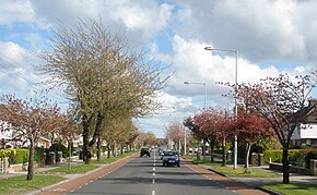
 R112 road with cycle lanes (red) | |
| Route information | |
| Length | 15.2 km[1] (9.4 mi) |
| Location | |
| Country | Ireland |
| Primary destinations |
|
| Highway system | |
The R112 road is a regional road in south Dublin, Ireland.[2] It begins at the junction with the R148 road at Chapelizod and arcs southeastwards, then eastwards across the middle of south Dublin, ending at the Mount Merrion junction of the R138. The road is a single-carriageway, with cycle lanes on some stretches. Improvements to the road have been made over the last 10 years, the most significant being at Dundrum Cross where the road was widened to make room for the new Luas bridge and Dundrum bypass (R117 road).
The official description of the R112 from the Roads Act 1993 (Classification of Regional Roads) Order 2012 [2] reads:
- R112: Chapelizod - Churchtown - Mount Merrion, County Dublin
- Between its junction with R148 at Chapelizod Bypass in the city of Dublin and its junction with R138 at Stillorgan Road in the county of Dun Laoghaire — Rathdown via Kylemore Road and Walkinstown Avenue in the city of Dublin: Saint Peters Road, Greentrees Road, Templeville Road and Springfield Avenue, Dodder View Road and Dodder Park Road in the county of South Dublin: Dodder Park Road, Braemor Road, Churchtown Road Upper, Taney Road, Mount Anville Road and Fosters Avenue in the county of Dun Laoghaire — Rathdown.
The R112 is 15.2 kilometres (9.4 mi) long (map of the road).


- ^ Map of the route of R112, Google Maps. Retrieved: 2010-08-06.
- ^ a b Statutory Instrument 54 of 2012 — Roads Act 1993 (Classification of Regional Roads) Order 2012, Irish Statute Book (irishstatutebook.ie). Retrieved 2017-02-02.
