This article needs additional citations for verification. (October 2010) |
| MoD Bovingdon USAAF Station 112 | |||||||||||
|---|---|---|---|---|---|---|---|---|---|---|---|
| Near Hemel Hempstead, Hertfordshire | |||||||||||
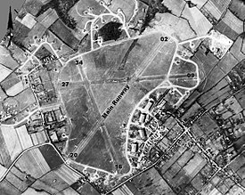
 Aerial photograph of Bovingdon airfield looking north , the technical site with four T2 hangars is at the southeast of the airfield, the bomb dump is to the west, 13 March 1944 | |||||||||||
| Coordinates | 51°43′37″N 000°32′36″W / 51.72694°N 0.54333°W | ||||||||||
| Code | BV, BZ (1940s); ZZ (1956) | ||||||||||
| Site information | |||||||||||
| Owner | Air Ministry | ||||||||||
| Operator | Royal Air Force[1] United States Army Air Forces United States Air Force | ||||||||||
| Controlled by | Eighth Air Force (1942–1946) RAF Flying Training Command (1947–1962) Strategic Air Command (1951–1962) RAF Transport Command (1962–1969) | ||||||||||
| Site history | |||||||||||
| Built | 1941 | ||||||||||
| In use | 1942–1972 | ||||||||||
| Battles/wars | Second World War
| ||||||||||
| Airfield information | |||||||||||
| Elevation | 500 ft (152 m)[2] AMSL | ||||||||||
| |||||||||||
Royal Air Force Bovingdon or more simply RAF Bovingdon is a former Royal Air Force station located near the village of Bovingdon, Hertfordshire, England, about 2.5 miles (4.0 km) south-west of Hemel Hempstead and 2.5 miles (4.0 km) south-east of Berkhamsted.
During the Second World War, the airfield was used by the Royal Air Force (RAF) and the United States Army Air Forces (USAAF) Eighth Air Force. It was assigned USAAF designation Station 112, station code "BV", later changed to "BZ".
- ^ Cite error: The named reference
CTwas invoked but never defined (see the help page). - ^ "RAF Bovingdon". Air of Authority - A History of RAF Organisation. Retrieved 9 April 2015.


