| RAF Croft | |||||||||||
|---|---|---|---|---|---|---|---|---|---|---|---|
| Dalton-on-Tees, North Yorkshire in England | |||||||||||
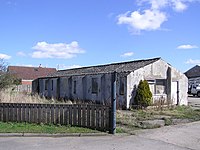
 A building at Cockleberry Saw Mill which was part of RAF Croft during the Second World War | |||||||||||
| Coordinates | 54°27′09″N 001°33′11″W / 54.45250°N 1.55306°W | ||||||||||
| Type | Royal Air Force satellite station 1941–43 64 (RCAF) Base substation 1943–[1] | ||||||||||
| Code | CR[1] | ||||||||||
| Site information | |||||||||||
| Owner | Air Ministry | ||||||||||
| Operator | Royal Air Force (RAF) Royal Canadian Air Force (RCAF) | ||||||||||
| Controlled by | RAF Bomber Command * No. 4 Group RAF * No. 6 Group RCAF[1] | ||||||||||
| Site history | |||||||||||
| Built | 1940/41 | ||||||||||
| In use | October 1941 – 1952 | ||||||||||
| Battles/wars | European theatre of World War II | ||||||||||
| Airfield information | |||||||||||
| Elevation | 55 metres (180 ft)[1] AMSL | ||||||||||
| |||||||||||
Royal Air Force Croft or more simply RAF Croft is a former Royal Air Force satellite station located 4.6 miles (7.4 km) south of Darlington, County Durham, England and 8 miles (13 km) north-east of Richmond, North Yorkshire. The site is also known locally as Croft Aerodrome or Neasham. Constructed at the same time as many other airfields, it was originally named RAF Dalton-on-Tees after the nearby village Dalton-on-Tees. However, it was quickly renamed RAF Croft (after Croft-on-Tees) after initial confusion with the also newly opened RAF Dalton near Thirsk, just 25 miles away.
The airfield was opened in 1941 for use by the Royal Air Force (RAF) but by 1942 the aerodrome had been taken over by the Royal Canadian Air Force (RCAF) for training as part of No. 6 Group RCAF.
The station is now the site of Croft Circuit, a motor racing circuit which hosts various car championships including the British Touring Car Championship.
- ^ a b c d Falconer 2012, p. 72.

