| RAF Martlesham Heath USAAF Station 369 | |||||||||
|---|---|---|---|---|---|---|---|---|---|
| Woodbridge, Suffolk in England | |||||||||
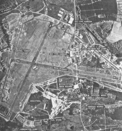
 Martlesham Heath Airfield - 9 July 1946 | |||||||||
| Coordinates | 52°03′29″N 1°15′58″E / 52.058°N 1.266°E | ||||||||
| Type | Royal Air Force station | ||||||||
| Code | MH[1] | ||||||||
| Site information | |||||||||
| Owner | Air Ministry | ||||||||
| Operator | Royal Flying Corps Royal Air Force United States Army Air Forces | ||||||||
| Controlled by | RAF Fighter Command * No. 11 Group RAF 1939-43 Eighth Air Force | ||||||||
| Site history | |||||||||
| Built | 1917 | ||||||||
| In use | January 1917 - 1963 | ||||||||
| Battles/wars | First World War European theatre of World War II Cold War | ||||||||
| Airfield information | |||||||||
| Elevation | 27 metres (89 ft)[1] AMSL | ||||||||
| |||||||||
Royal Air Force Martlesham Heath or more simply RAF Martlesham Heath is a former Royal Air Force station located 1.5 miles (2.4 km) southwest of Woodbridge, Suffolk, England. It was active between 1917 and 1963, and played an important role in the development of airborne radar.
- ^ a b Falconer 2012, p. 137.


