This article includes a list of general references, but it lacks sufficient corresponding inline citations. (June 2012) |
| RAF Upper Heyford | |||||||
|---|---|---|---|---|---|---|---|
| Upper Heyford, Oxfordshire in England | |||||||
 | |||||||
| Coordinates | 51°56′13″N 001°15′12″W / 51.93694°N 1.25333°W | ||||||
| Type | RAF flying station (US Visiting Forces) | ||||||
| Code | UH | ||||||
| Site information | |||||||
| Owner | Ministry of Defence | ||||||
| Operator | Royal Air Force (1918–1919) Royal Air Force (1927–1950) United States Air Force (1950–1994) | ||||||
| Controlled by | RAF Bomber Command * No. 6 (T) Group RAF * No. 92 (OTU) Group RAF | ||||||
| Condition | Closed | ||||||
| Site history | |||||||
| Built | 1918 | ||||||
| Built by | John Laing & Son Ltd[1] | ||||||
| In use | 1918–1919 October 1927–1994 | ||||||
| Fate | |||||||
| Battles/wars | European theatre of World War II Cold War | ||||||
| Airfield information | |||||||
| Identifiers | IATA: UHF, ICAO: EGUA, WMO: 03655 | ||||||
| Elevation | 132 metres (433 ft) AMSL | ||||||
| |||||||
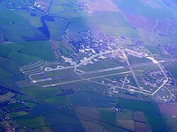
Royal Air Force Upper Heyford or more simply RAF Upper Heyford is a former Royal Air Force station located 5 miles (8 km) north-west of Bicester near the village of Upper Heyford, Oxfordshire, England. In the Second World War the airfield was used by RAF Bomber Command. During the Cold War, Upper Heyford was one of the former RAF bases chosen to house the United States Air Force Strategic Air Command (SAC) nuclear-capable bombers on 90-day TDY (Temporary Duty) deployments until 1959, SAC Reflex Alert deployments from 1959 until 1965, from 1966 United States Air Forces in Europe (USAFE) tactical reconnaissance aircraft, and from 1970 General Dynamics F-111 Aardvark strike aircraft.
- ^ Falconer 2012, p. 199.


