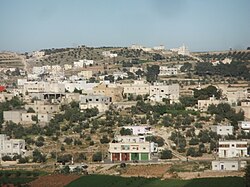
Rabud | |
|---|---|
| Arabic transcription(s) | |
| • Arabic | رابود |
| • Latin | Khirbet Rabud (official) |
 Rabud | |
| Coordinates: 31°26′0″N 35°1′0″E / 31.43333°N 35.01667°E | |
| Palestine grid | 151/093 |
| State | State of Palestine |
| Governorate | Hebron |
| Government | |
| • Type | Village council (from 1993) |
| • Head of Municipality | Muhammad Huraibat[1] |
| Area | |
| • Total | 2,200 dunams (2.2 km2 or 0.8 sq mi) |
| Population (2017)[2] | |
| • Total | 2,816 |
| • Density | 1,300/km2 (3,300/sq mi) |
Rabud (Arabic: رابود, also spelled Khirbet Rabud) is a Palestinian village in the southern West Bank, in the Hebron Governorate of the State of Palestine. The village was the site of an ancient Canaanite city. The village had a population of 2,816 in 2017.[2]
- ^ Rabud Profile. Jerusalem Media and Communications Center (JMCC).
- ^ a b Preliminary Results of the Population, Housing and Establishments Census, 2017 (PDF). Palestinian Central Bureau of Statistics (PCBS) (Report). State of Palestine. February 2018. pp. 64–82. Retrieved 2023-10-24.

