| Rafferty Peak | |
|---|---|
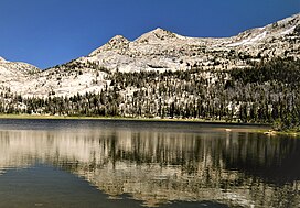
 Southwest aspect, reflected in Nelson Lake | |
| Highest point | |
| Elevation | 11,110 ft (3,386 m)[1] |
| Prominence | 190 ft (58 m)[2] |
| Isolation | 1.0 mi (1.6 km)[3] |
| Coordinates | 37°48′55″N 119°21′20″W / 37.8151546°N 119.3554826°W[4] |
| Naming | |
| Etymology | Ogden Rafferty |
| Geography | |
| Location | Yosemite National Park Mariposa / Tuolumne counties California, U.S. |
| Parent range | Cathedral Range, Sierra Nevada |
| Topo map | USGS Vogelsang Peak |
| Geology | |
| Rock age | Cretaceous |
| Mountain type | Fault block |
| Rock type | Granodiorite |
| Climbing | |
| First ascent | Edward W. Hernden[5] |
| Easiest route | class 2[3] |
Rafferty Peak is an 11,110-foot-elevation (3,386 meter) mountain summit located in Yosemite National Park, in California, United States. It is situated on the common border shared by Mariposa and Tuolumne Counties. It is set south of Tuolumne Meadows in the Cathedral Range which is a sub-range of the Sierra Nevada mountain range. The mountain rises one mile (1.6 km) northwest of Tuolumne Pass, 1.4 mile south of Johnson Peak, and 2.5 miles east of Matthes Crest. Tuolumne Pass is the low point of the saddle between Rafferty Peak and Fletcher Peak. Topographic relief is significant as the summit rises 1,500 feet (460 meters) above Nelson Lake in one mile.
- ^ R. J. Secor, The High Sierra Peaks, Passes, Trails, 2009, Third Edition, Mountaineers Books, ISBN 9781594857386
- ^ "Rafferty Peak, California". Peakbagger.com. Retrieved 2022-06-13.
- ^ a b "Rafferty Peak - 11,110' CA". listsofjohn.com. Retrieved 2022-06-13.
- ^ "Rafferty Peak". Geographic Names Information System. United States Geological Survey, United States Department of the Interior. Retrieved 2022-06-13.
- ^ Edward S. Robbins and Alfred W. Baxter, Jr., A Climber's Guide to the High Sierra (1954)

