| Rainbow Dam | |
|---|---|
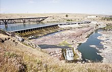
 Rainbow Dam and Rainbow Falls in 2000 | |
| Official name | Rainbow Dam |
| Location | Cascade County, Montana, US |
| Coordinates | 47°32′04″N 111°12′18″W / 47.53444°N 111.20500°W |
| Opening date | 1910 |
| Operator(s) | NorthWestern Corporation |
| Dam and spillways | |
| Impounds | Missouri River |
| Height | 29 ft (8.8 m) |
| Length | 1,055 ft (321.6 m) |
| Power Station | |
| Installed capacity | 36 MW |
| Annual generation | 268,070,000 KWh (2009)[1] |
Rainbow Dam is a hydroelectric dam on the Missouri River, 29 feet (8.8 m) high and 1,055 feet (322 m) long, located six miles northeast of Great Falls in the U.S. state of Montana.[2]
- ^ "Rainbow". Carbon Monitoring for Action. Retrieved 2018-04-26.
- ^ "Rainbow Dam". PPL Montana. Retrieved 2009-03-28.