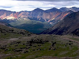
| Rainbow Range | |
|---|---|
| Rainbow Mountains | |
 Rainbow Range colours from heavy mineralization | |
| Highest point | |
| Peak | Tsitsutl Peak |
| Elevation | 2,495 m (8,186 ft)[1] |
| Coordinates | 52°43′24″N 125°46′48″W / 52.72333°N 125.78000°W[2] |
| Geography | |
 | |
| Country | Canada |
| Province | British Columbia |
| District | Range 3 Coast Land District |
| Range coordinates | 52°42′59″N 125°49′05″W / 52.71639°N 125.81806°W[3] |
| Parent range | Chilcotin Plateau |
| Borders on | Pacific Ranges, Kitimat Ranges, Ilgachuz Range |
| Topo map | NTS 93C12 Tusulko River |
| Geology | |
| Formed by | Shield volcano |
| Orogeny | Anahim hotspot volcanism |
| Rock age | 8.7 to 7.2 million years |
The Rainbow Range, formerly gazetted as the Rainbow Mountains,[3] is a mountain range in British Columbia, Canada, located 40 kilometres (25 mi) northwest of Anahim Lake. Located on the western edge of the Chilcotin Plateau, the range adjoins the Coast Mountains Pacific Ranges to the south, and the Kitimat Ranges to the north. In some classification systems it is considered[by whom?] part of the Coast Mountains. It lies north of the Bella Coola and Atnarko Rivers and south and west of the Dean River, which curves around its north flank, and is relatively drier in climate and easier of terrain than more mountainous areas immediately west.
Once called Tsitsutl, meaning "rainbow mountains" in the Ulkatcho dialect of the Carrier language,[4] that name is now the name of the range's highest peak.
- ^ "Tsitsutl Peak". Bivouac.com. Retrieved 2023-06-28.
- ^ "Tsitsutl Peak". BC Geographical Names. Retrieved 2023-06-28.
- ^ a b "Rainbow Range". BC Geographical Names. Retrieved 2023-06-28.
- ^ "Tweedsmuir Park: Nature and culture". BC Parks. Retrieved 2023-06-28.