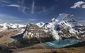
| Rainbow Range | |
|---|---|
 | |
| Highest point | |
| Peak | Mount Robson |
| Elevation | 3,954 m (12,972 ft)[1] |
| Prominence | 2,829 m (9,281 ft)[2] |
| Listing | |
| Coordinates | 53°06′38″N 119°09′23″W / 53.11056°N 119.15639°W[3] |
| Dimensions | |
| Area | 497 km2 (192 sq mi)[4] |
| Geography | |
| Country | Canada |
| Provinces | |
| Range coordinates | 53°03′N 119°03′W / 53.050°N 119.050°W[5] |
| Parent range | Canadian Rockies |
| Topo map | NTS 83D15 Lucerne[5] |
The Rainbow Range is a small subrange of the Park Ranges subdivisions of the Northern Continental Ranges of the Rocky Mountains on the border between Alberta and British Columbia in Mount Robson Provincial Park.
Its highest summit, and the highest in the Canadian Rockies, is Mount Robson 3,954 m (12,972 ft), followed by nearby Resplendent Mountain 3,425 m (11,237 ft).
- ^ Cite error: The named reference
bcparks_robsonwas invoked but never defined (see the help page). - ^ "Mount Robson". Bivouac.com. Retrieved 2023-07-15.
- ^ "Mount Robson". Geographical Names Data Base. Natural Resources Canada. Retrieved 2019-08-19.
- ^ "Rainbow Range". Peakbagger.com. Retrieved 2012-05-19.
- ^ a b "Rainbow Range". BC Geographical Names. Retrieved 2012-05-19.


