| Rainow | |
|---|---|
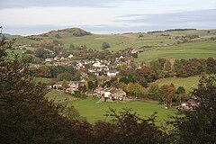
 Rainow from the west | |
Location within Cheshire | |
| Population | 2,505 |
| OS grid reference | SJ950761 |
| Civil parish |
|
| Unitary authority | |
| Ceremonial county | |
| Region | |
| Country | England |
| Sovereign state | United Kingdom |
| Post town | MACCLESFIELD |
| Postcode district | SK10 |
| Dialling code | 01625 |
| Police | Cheshire |
| Fire | Cheshire |
| Ambulance | North West |
| UK Parliament | |
Rainow is a village and civil parish in Cheshire, England, in the valley of the River Dean and next to the B5470 road between Macclesfield and Kettleshulme. It straddles the eastern side of the Peak District border of Derbyshire and Cheshire,[1] and is surrounded by pasture farmland. The Peak District Boundary Walk runs past the village.[2] The village's name comes from the Old English hræfn + hōh, meaning "hill-spur frequented by ravens".[3] It is a former mill village and has a population of around 2,500.[4]
To the east of the village is Lamaload Reservoir, the first concrete reservoir constructed in England, between 1958 and 1964. At 308 metres (1,010 ft), it is also the highest constructed dam in England.[5]
White Nancy, a circular, white-painted stone structure constructed to celebrate the anniversary of the Battle of Waterloo, stands at the northern end of Kerridge Hill on the boundary between the parishes of Rainow and Bollington.
- ^ Rainow Village Website
- ^ McCloy, Andrew (2017). Peak District Boundary Walk: 190 Miles Around the Edge of the National Park. Friends of the Peak District. ISBN 978-1909461536.
- ^ Mills, A. D. (1997) [1991]. A Dictionary of English Place Names. Oxford: Oxford University Press. p. 267. ISBN 0192831313.
- ^ Rainow Ward Profile - 2001 Census Archived 2006-01-12 at the Wayback Machine
- ^ Revisiting Lamaload, 41 years on. Blueprint: the News Magazine of Costain Group 26 (Spring 2004) Archived 2007-09-27 at the Wayback Machine
