Rajgir
Rajagriha | |
|---|---|
Town | |
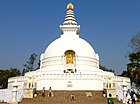
From top, left to right: View of Rajgir hills, Vishwa Shanti Stupa (peace pagoda), Vulture Peak, Ghora Katora lake, Naulakha Jain Temple | |
 Interactive map of Rajgir | |
| Coordinates: 25°1′48″N 85°25′12″E / 25.03000°N 85.42000°E | |
| Country | |
| State | |
| Region | Magadha |
| Division | Patna |
| District | Nalanda |
| Founded | ≈2000 BC |
| Founded by | Brihadratha |
| Government | |
| • Type | Municipal governance in India |
| • Body | Rajgir Municipal Council (Nagar Parishad) |
| Area (2015) [A 1] | |
• Total | 111.39 km2 (43.01 sq mi) |
| • Town | 61.6 km2 (23.8 sq mi) |
| • Regional planning | 517 km2 (200 sq mi) |
| Elevation | 73 m (240 ft) |
| Population (2011)[2] | |
| • Rajgir (NP) | 41,587 |
| • Rajgir (CD Block) | 88,596 |
| Time zone | UTC+5:30 (IST) |
| PIN | 803116 |
| Telephone code | +91-6112 |
| Vehicle registration | BR-21 |
| Sex ratio | 1000/889 ♂/♀ |
| Literacy | 51.88% |
| Lok Sabha constituency | Nalanda |
| Vidhan Sabha constituency | Rajgir (SC) (173) |
| Website | nalanda |
Rajgir, old name Rajagriha, meaning "The City of Kings," is an ancient city and university town in the district of Nalanda in Bihar, India. As the ancient seat and capital of the Haryanka dynasty, the Pradyota dynasty, the Brihadratha dynasty and the Mauryan Empire, as well as the dwelling ground of such historical figures as Buddha, Mahavira and Bimbisara, the city holds a place of prominence in Hindu, Buddhist and Jain scriptures. As of 2011, the population of the town was reported to be 41,000 while the population in the community development block was about 88,500.
Rajgir was the first capital of the ancient kingdom of Magadha, a state that would eventually evolve into the Mauryan Empire.[3] It finds mention in India's renowned literary epic, the Mahabharata, through its king Jarasandha. The town's date of origin is unknown, although ceramics dating to about 1000 BC have been found in the city. The 2,500-year-old cyclopean wall is also located in the region.
The ancient Nalanda university was located in the vicinity of Rajgir, and the contemporary Nalanda University named after it was founded in 2010 nearby. The town is also famed for its natural springs and towering hills that dominate the landscape.
- ^ "पत्रांक-213 : राजगीर क्षेत्रीय आयोजना क्षेत्र एवं बोधगया आयोजना क्षेत्र के सीमांकन एवं घोषणा" (PDF). Urban Development Housing Dept., Government of Bihar, Patna. 15 April 2015. Archived (PDF) from the original on 18 June 2015. Retrieved 18 May 2015.
- ^ Cite error: The named reference
Census2011Govwas invoked but never defined (see the help page). - ^ "Rajgir". BSTDC. Bihar State Tourism Development Corporation. Retrieved 29 March 2022.


