Rajsamand district | |
|---|---|
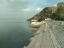
Clockwise from top-left: Kumbalgarh Fort, Anjana Fort, Third Eye Circle in Nathdwara, Rajsamand Lake, Statue of Maharana Pratap at Haldighati | |
 | |
| Coordinates: 25°04′N 73°52′E / 25.067°N 73.867°E | |
| Country | |
| State | Rajasthan |
| Division | Udaipur |
| Headquarter | Rajsamand |
| Established | 10 April 1991 |
| Founded by | Rana Raj Singh |
| Named for | Rajsamand lake |
| Area | |
• Total | 4,550.93 km2 (1,757.12 sq mi) |
| • Rank | 19 |
| Population (2011)[1] | |
• Total | 1,156,597 |
| • Density | 217/km2 (560/sq mi) |
| Languages | |
| • Official | Hindi, Rajasthani |
| • Regional | Mewari |
| Time zone | UTC+5:30 (IST) |
| PIN | 313324/26 |
| Telephone code | 02952 |
| Vehicle registration | RJ-30 |
| Lok Sabha constituency | Rajsamand (Lok Sabha constituency) |
| Nearest city | Udaipur, Chittorgarh, Bhilwara, Ajmer |
| Avg. annual temperature | 22.5 °C (72.5 °F) |
| Avg. summer temperature | 45 °C (113 °F) |
| Avg. winter temperature | 00 °C (32 °F) |
| Website | rajsamand |
Rajsamand District is a district of the state of Rajasthan in western India. The city of Rajsamand is the district headquarters. The district was constituted on 10 April 1991 from Udaipur district by carving out 7 tehsils - Bhim, Deogarh, Amet, Kumbhalgarh, Rajsamand, Nathdwara, and Railmagra.[2]
- ^ Cite error: The named reference
districtcensuswas invoked but never defined (see the help page). - ^ District Census Handbook Rajsamand PART XII-A (PDF). Directorate of Census Operations. 2011. Retrieved 30 March 2019.


