| Rakitnica Ракитница | |
|---|---|
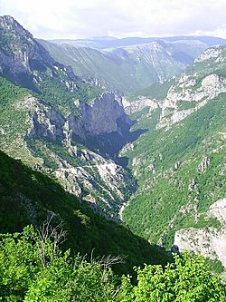
 Upstream view on the Rakitnica river, squeezed in a deep narrow canyon between Bjelašnica (on the left) and Visočica (on the right). | |
 | |
| Location | |
| Country | Bosnia and Herzegovina |
| Physical characteristics | |
| Source | Zucina Vrela |
| • location | Above Rakitnica village under the northwestern ridge of Treskavica mountain. |
| • coordinates | 43°38′04″N 18°19′03″E / 43.634420°N 18.317633°E |
| • elevation | 1,270 m (4,170 ft) |
| 2nd source | Confluence of Crna Rijeka & Glibovac |
| • location | 2 kilometers downstream of Zucina Vrela |
| • coordinates | 43°38′35″N 18°17′59″E / 43.6430165°N 18.2998538°E |
| • elevation | 1,200 m (3,900 ft) |
| Mouth | |
• location | The Neretva river between Glavatičevo and Konjic |
• coordinates | 43°33′16″N 18°04′12″E / 43.5544°N 18.0700°E |
• elevation | 323 m (1,060 ft) |
| Length | 33 km (21 mi) |
| Basin features | |
| Progression | Neretva→ Adriatic Sea |
| Landmarks | Lukomir, Stećak's UNESCO World Heritage Site |
| Tributaries | |
| • left | Glibovac, Pijevac, Velaškovac, Tušilska Rijeka, Međeđa, Grušćanska Rijeka |
| • right | Veliki Do, Lađevac, Kolijevka, Potoci, Zapolje, Šklope, Studenac |
| Waterbodies | Blatačko Lake |
| Waterfalls | Peruće |
Rakitnica (Serbian Cyrillic: Ракитница) is the main tributary of the first section of the Neretva river, also called Upper Neretva (Bosnian: Gornja Neretva). It meets Neretva from the right, flowing from north to south, between Bjelašnica and Visočica mountains.[1]
- ^ "SummitPost - Rakitnica inside -- Photo Albums". www.summitpost.org. Archived from the original on 24 February 2011. Retrieved 18 April 2022.
