This article has multiple issues. Please help improve it or discuss these issues on the talk page. (Learn how and when to remove these messages)
|
Ramgarh district | |
|---|---|
Damodar River, Chhinnmasta Mandir, Rajrappa | |
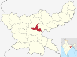
 Location of Ramgarh district in Jharkhand | |
| Country | |
| State | |
| Division | North Chotanagpur |
| Seat | Ramgarh Cantonment |
| Tehsils | Ramgarh |
| Government | |
| • District Commissioner | Madhvi Mishra, IAS |
| • Lok Sabha constituencies | Hazaribagh |
| • Vidhan Sabha constituencies | Ramgarh, Mandu, Barkagaon |
| Area | |
• Total | 1,341 km2 (518 sq mi) |
| • Rank | 23 |
| Population (2011) | |
• Total | 949,443 |
| • Rank | 24 |
| • Density | 710/km2 (1,800/sq mi) |
| • Urban | 4,372 |
| Demographics | |
| • Literacy | 73.17% |
| • Sex ratio | 921 |
| Time zone | UTC+05:30 (IST) |
| Vehicle registration | JH-24 |
| Major highways | NH 20 and NH 23 |
| Website | ramgarh |
Ramgarh district is one of the 24 districts in the Indian state of Jharkhand. It was also a military district during the British Regime, referred to then as Ramgarh district. It is the part of State Capital Region (SCR).
Ramgarh was made a district on 12 September 2007. It was carved out of erstwhile Hazaribagh District. Ramgarh lies at the heart of the Jharkhand state. It is a mining, industrial and cultural hub with the Maa Chhinnamasta Temple.[1] In 1670s, the king Dalel Singh shifted the capital of Ramgarh Raj to Ramgarh and named it after his father Ram Singh. The district of Ramgarh has been named after the town Ramgarh, its present headquarters.
- ^ "Archived copy". Archived from the original on 30 December 2013. Retrieved 27 August 2012.
{{cite web}}: CS1 maint: archived copy as title (link)

