| Rammelsberg | |
|---|---|
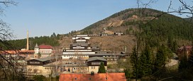
 Mining museum on the slopes of Rammelsberg | |
| Highest point | |
| Elevation | 635 m (2,083 ft) |
| Coordinates | 51°53′25″N 10°25′08″E / 51.89028°N 10.41889°E |
| Geography | |
Lower Saxony, Germany | |
| Parent range | Harz Mountains |
| Topo map | |
| Part of | Mines of Rammelsberg, Historic Town of Goslar and Upper Harz Water Management System |
| Criteria | Cultural: i, ii, iii, iv |
| Reference | 623-001 |
| Inscription | 1992 (16th Session) |
| Area | 363.3 ha (898 acres) |
| Buffer zone | 376.1 ha (929 acres) |
The Rammelsberg is a mountain, 635 metres (2,083 ft) high, on the northern edge of the Harz range, south of the historic town of Goslar in the North German state of Lower Saxony. The mountain is the location of an important silver, copper, and lead mine. When it closed in 1988, it had been the only mine still working continuously for over 1,000 years.[1] Because of its long history of mining and testimony to the advancement and exchange of technology over many centuries, the visitor mine of Rammelsberg was inscribed as a UNESCO World Heritage Site in 1992.[1][2]
- ^ a b Cite error: The named reference
Knollewas invoked but never defined (see the help page). - ^ "Mines of Rammelsberg, Historic Town of Goslar and Upper Harz Water Management System". UNESCO World Heritage Centre. United Nations Educational, Scientific, and Cultural Organization. Retrieved 25 June 2022.

