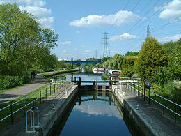
| Rammey Marsh Lock | |
|---|---|
 Rammey Marsh Lock looking north towards the M25 road bridge | |
 | |
| 51°40′41″N 0°00′43″W / 51.678184°N 0.012073°W | |
| Waterway | River Lee Navigation |
| County | London Borough of Enfield Greater London |
| Maintained by | Canal & River Trust |
| Operation | Manual |
| First built | 1864 |
| Length | 85 feet (25.9 m) |
| Width | 16 feet (4.9 m) |
| Fall | 3 feet 3 inches (1 m) |
| Distance to Bow Creek | 12.3 miles (19.8 km) |
| Distance to Hertford Castle Weir | 14.0 miles (22.5 km) |
Rammey Marsh Lock (No 12) is a lock on the River Lee Navigation at Enfield, London, England. The area adjacent to the lock is known as Rammey Marsh and close to the River Lee Flood Relief Channel.