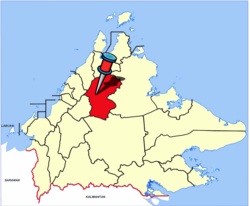
Ranau District | |
|---|---|
| Daerah Ranau | |
| Other transcription(s) | |
| • Jawi | داءيره راناو |
| • Chinese | 兰瑙县 (Simplified) 蘭瑙縣 (Traditional) Lánnǎo xiàn (Hanyu Pinyin) |
| • Tamil | ரானாவ் மாவட்டம் Rāṉāv māvaṭṭam (Transliteration) |
| • Kadazandusun | Watas Ranau |
 Ranau District Office. | |
 | |
| Coordinates: 5°58′00″N 116°41′00″E / 5.96667°N 116.68333°E | |
| Country | |
| State | |
| Division | West Coast |
| Capital | Ranau |
| Government | |
| • District Officer | Tinus Manggam |
| Area | |
• Total | 3,608.51 km2 (1,393.25 sq mi) |
| Elevation | 1,176 m (3,858 ft) |
| Population (2020) | |
• Total | 118,092 |
| Website | ww2 ww2 |
The Ranau District (Malay: Daerah Ranau) is an administrative district in the Malaysian state of Sabah, part of the West Coast Division which includes the districts of Kota Belud, Kota Kinabalu, Papar, Penampang, Putatan, Ranau and Tuaran. The capital of the district is in Ranau Town. The landlocked district bordering the Sandakan Division to the east until it meets the Interior Division border. Ranau sits 108 km (67 mi) east of Kota Kinabalu[1] and 227 km (141 mi) west of Sandakan.[2] As of the 2010 Census, the population of the district was 94,092,[3] an almost entirely Dusun ethnic community.[4][5]
Ranau is noted for its hilly geographical structure and is the largest producer of highland vegetables in the state of Sabah.[6] Tourism and highland agriculture are the major industries, as the district is at an altitude of 1,176 m above sea level.[4] Its many tourist destinations attracted half a million tourists in 2009.[7] These include Mount Kinabalu, Kinabalu Park, Poring Hot Springs, Kundasang War Memorial, Death March Trail, Mesilau, and Sabah Tea Garden. Ranau's diverse flora ranges from rich tropical lowland and hill rainforest to tropical mountain, sub-alpine forest and scrub on the higher elevations and particularly abundant in species with examples of flora from as far as China, Australia and the Himalayas, as well as pan-tropical flora.[8]
Kinabalu Park has been recognised by UNESCO as a Centre of Plant Diversity for Southeast Asia.[8] In December 2000, the Kinabalu Park was designated by UNESCO as Malaysia's first World Heritage Site.[8]
Ranau was home to the largest mining project in Malaysia, the Mamut Copper Mine,[9] before it ceased operations in 1999.[10] At the peak of its mining activity, Ranau was transformed into a thriving township. The mining company constructed the Ranau Bridge across Liwagu River, the Ranau Golf Course, and also made donations to school building funds, buses, and bus shelters.[11]
- ^ (in Malay) "Location Background of Ranau". Ranau Education Office. Retrieved 6 February 2012.
- ^ "Distance from Ranau to Sandakan"[permanent dead link]. Google Maps. Retrieved 6 February 2012.
- ^ "Population by ethnic group, Local Authority area and state, Malaysia" (PDF). Department of Statistics, Malaysia. 2010. Archived from the original (PDF) on 27 February 2012. Retrieved 5 November 2017.
- ^ a b "Destinations: Places To Go - Ranau" Archived 3 February 2012 at the Wayback Machine. Sabah Tourism Board. Retrieved 6 February 2012.
- ^ Cite error: The named reference
ethnicwas invoked but never defined (see the help page). - ^ "Ranau meteorological station to start operations in January". The Borneo Post. 8 November 2011. Retrieved 6 February 2012.
- ^ (in Malay) "More Than Half A Million Tourists Visited Ranau Last Year" Archived 24 February 2013 at the Wayback Machine. Kadazandusun Cultural Association. 3 June 2010. Retrieved 6 February 2012.
- ^ a b c "Kinabalu Park". World Heritage Centre, United Nations Educational, Scientific and Cultural Organization (UNESCO). Retrieved 6 February 2012.
- ^ Mamut Copper Mining Sdn. Bhd. 1996, p. 6
- ^ Chiew, Hilary. 2 October 2007. "Poisonous wasteland" Archived 20 March 2011 at the Wayback Machine. The Star, Retrieved 6 February 2012.
- ^ Mamut Copper Mining Sdn. Bhd. 1996, p. 24
