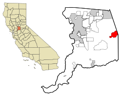
Rancho Murieta | |
|---|---|
 Location in Sacramento County and the state of California | |
| Coordinates: 38°30′11″N 121°5′5″W / 38.50306°N 121.08472°W | |
| Country | |
| State | |
| County | Sacramento |
| Area | |
| • Total | 12.068 sq mi (31.26 km2) |
| • Land | 11.887 sq mi (30.79 km2) |
| • Water | 0.181 sq mi (0.47 km2) 1.50% |
| Elevation | 167 ft (51 m) |
| Population (2020) | |
| • Total | 5,903[1] |
| Time zone | UTC-8 (PST) |
| • Summer (DST) | UTC-7 (PDT) |
| ZIP code | 95683 |
| Area code(s) | 916, 279 |
| FIPS code | 06-59506 |
| GNIS feature ID | 1820537 |

Rancho Murieta is a census-designated place (CDP) and guard-gated community in Sacramento County, California, United States. It is part of the Sacramento–Arden-Arcade–Roseville Metropolitan Statistical Area. The population was 5,488 at the 2010 census, up from 4,193 at the 2000 census. It is located in the foothills of the Sierra Nevada range, about 25 miles (40 km) east of Sacramento.
- ^ "Explore Census Data". data.census.gov. Retrieved May 1, 2023.
- ^ "U.S. Census". Archived from the original on July 2, 2012.[dead link]