Rancho Santa Fe | |
|---|---|
 | |
| Nickname: The Ranch | |
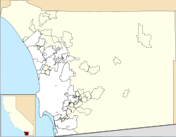
 Location in San Diego County, California. | |
| Coordinates: 33°1′26″N 117°12′0″W / 33.02389°N 117.20000°W | |
| Country | |
| State | California |
| County | San Diego |
| Area | |
| • Total | 6.788 sq mi (17.581 km2) |
| • Land | 6.715 sq mi (17.392 km2) |
| • Water | 0.073 sq mi (0.189 km2) 1.07% |
| Elevation | 246 ft (75 m) |
| Population | |
| • Total | 3,156 |
| • Density | 460/sq mi (180/km2) |
| Time zone | UTC−8 (Pacific Time Zone) |
| • Summer (DST) | UTC−7 (PDT) |
| ZIP codes | 92067, 92091 |
| Area code | 858 |
| FIPS code | 06-59584 |
| GNIS feature IDs | 247968, 2409138 |
| Reference no. | 982[3] |
Rancho Santa Fe is a census-designated place (CDP) in San Diego County, California, United States, within the San Diego metropolitan area. The population was 3,156 at the 2020 census. The CDP is primarily residential with a few shopping blocks, a middle and elementary school, and several restaurants.
Rancho Santa Fe borders the Fairbanks Ranch gated community to the southeast, Solana Beach to the southwest, and Encinitas to the west.
- ^ "2010 Census U.S. Gazetteer Files – Places – California". United States Census Bureau.
- ^ "Rancho Santa Fe". Geographic Names Information System. United States Geological Survey, United States Department of the Interior. Retrieved February 11, 2015.
- ^ Cite error: The named reference
CHLwas invoked but never defined (see the help page).


