| Randolph Air Force Base | |||||||||
|---|---|---|---|---|---|---|---|---|---|
| Bexar County, Texas Near Universal City, Texas in the United States | |||||||||
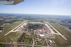
 Aerial view of Randolph AFB in 2009 | |||||||||
| Coordinates | 29°31′46″N 098°16′44″W / 29.52944°N 98.27889°W | ||||||||
| Type | US Air Force Base | ||||||||
| Site information | |||||||||
| Owner | Department of Defense | ||||||||
| Operator | US Air Force | ||||||||
| Website | Official website (archived) | ||||||||
| Site history | |||||||||
| Built | 1928 – 1930 (as Randolph Field) | ||||||||
| In use | 1930 – 1 October 2010 | ||||||||
| Fate | Merged in 2010 to become an element of Joint Base San Antonio | ||||||||
| Airfield information | |||||||||
| Identifiers | IATA: RND, ICAO: KRND, FAA LID: RND, WMO: 722536 | ||||||||
| Elevation | 232 metres (761 ft) AMSL | ||||||||
| |||||||||
Randolph Air Force Base (IATA: RND, ICAO: KRND, FAA LID: RND) is a United States Air Force base located in Bexar County, Texas,[1] (14.8 miles (23.8 km) east-northeast of Downtown San Antonio).
Opened in 1931, Randolph has been a flying training facility for the United States Army Air Corps, the United States Army Air Forces, and the Air Force during its entire existence.
On 1 October 2010, Randolph AFB merged with Lackland Air Force Base and the US Army's Fort Sam Houston to form Joint Base San Antonio.[2]
- ^ "2020 CENSUS - CENSUS BLOCK MAP (INDEX): Randolph AFB CDP, TX" (PDF). U.S. Census Bureau. Retrieved 29 October 2024.
- ^ "Joint Base San Antonio 502d ABW". 502abw.af.mil. Retrieved 15 August 2012.


