 NASA picture of Rapa | |
| Geography | |
|---|---|
| Location | Pacific Ocean |
| Coordinates | 27°36′S 144°20′W / 27.600°S 144.333°W |
| Archipelago | Australes |
| Area | 40.5 km2 (15.6 sq mi) |
| Highest elevation | 650 m (2130 ft) |
| Highest point | Mount Perahu |
| Administration | |
France | |
| Overseas collectivity | French Polynesia |
| Commune | Rapa Iti |
| Demographics | |
| Population | 451[1] (2022) |
Rapa | |
|---|---|
 | |
| Coordinates: 27°36′S 144°20′W / 27.60°S 144.33°W | |
| Country | France |
| Overseas collectivity | French Polynesia |
| Subdivision | Austral Islands |
| Government | |
| • Mayor (2020–2026) | Tuanainai Narii[2] |
| Area 1 | 40.54 km2 (15.65 sq mi) |
| Population (2022)[1] | 451 |
| • Density | 11/km2 (29/sq mi) |
| Time zone | UTC−10:00 |
| INSEE/Postal code | 98741 /98751 |
| Elevation | 0–650 m (0–2,133 ft) |
| 1 French Land Register data, which excludes lakes, ponds, glaciers > 1 km2 (0.386 sq mi or 247 acres) and river estuaries. | |
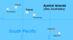
Rapa, also called Rapa Iti, or "Little Rapa", to distinguish it from Easter Island, whose Polynesian name is Rapa Nui, is the largest and only inhabited island of the Bass Islands in French Polynesia. An older name for the island is Oparo.[3] The total land area including offshore islets is 40.5 km2 (15.6 sq mi).[4]: 205 As of the 2022 census, Rapa had a population of 451.[1] The island's highest point is at 650 metres (2,130 ft) elevation at Mont Perahu.[4]: 243 Its main town is Ahuréi. The inhabitants of Rapa Iti speak their own Polynesian language called the Rapa language.
- ^ a b c "Les résultats du recensement de la population 2022 de Polynésie française" [Results of the 2022 population census of French Polynesia] (PDF) (in French). Institut de la statistique de la Polynésie française. January 2023.
- ^ "Répertoire national des élus: les maires" (in French). data.gouv.fr, Plateforme ouverte des données publiques françaises. 13 September 2022.
- ^ Tahiti guide
- ^ a b Environnement marin des îles Australes


