Native name: Ras Nouadhibou رأس نواذيبو Cabo Blanco Cap Blanc | |
|---|---|
 | |
| Geography | |
| Location | Africa |
| Coordinates | 20°46′17″N 17°2′50″W / 20.77139°N 17.04722°W |
| Adjacent to | |
| Length | 60 km (37 mi) |
| Width | 12 km (7.5 mi) |
| Administration | |
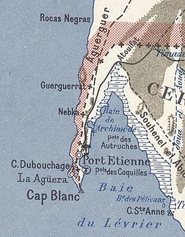
Ras Nouadhibou (Arabic: رأس نواذيبو) is a 60-kilometre (37 mi) peninsula or headland divided by the border between Mauritania and Western Sahara on the African coast of the Atlantic Ocean. It is internationally known as Cabo Blanco in Spanish or Cap Blanc in French (both meaning "White Headland").
In the 14th and 15th centuries, fishing activities carried out from the nearby Canary Islands, by Spanish fishermen, inspired Spain to develop an interest in the desert coast of what is today called Western Sahara.[citation needed]
Cabo Blanco in the Atlantic Ocean along with the island of Gyaros in the eastern Mediterranean are the only places in the world where Mediterranean monk seals preserve the structure of a colony.[1] In 1997, two-thirds of the colony died off, but there has been gradual recovery since.[2]
Although it is not the westernmost point of Africa, due to the Earth's tilt it is at least twice a year the last place in Africa where the sun sets.[3]
- ^ Karamanlidis, A; Dendrinos, P. "Monachus monachus". IUCN Red List of Threatened Species. doi:10.2305/IUCN.UK.2015-4.RLTS.T13653A45227543.en. Retrieved 3 July 2023.
- ^ Forcada, J.; Hammond, P.S.; Aguilar, A. (November 1999). "Status of the Mediterranean monk seal Monachus monachus in the western Sahara and the implications of a mass mortality event". Marine Ecology Progress Series. 188: 249–261. Bibcode:1999MEPS..188..249F. doi:10.3354/meps188249.
- ^ Jorge Mira-Pérez (2018). "The last sunset on mainland Europe". Cartography and Geographic Information Science. 45 (1). doi:10.1080/15230406.2016.1249409. hdl:10347/18512.
