Rauland Municipality
Rauland herad | |
|---|---|
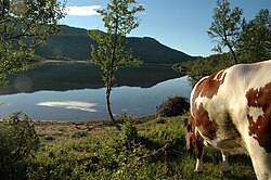
 Rural area in Rauland | |
 Telemark within Norway | |
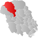
 Rauland within Telemark | |
| Coordinates: 59°42′59″N 7°59′18″E / 59.71631°N 7.98844°E | |
| Country | Norway |
| County | Telemark |
| District | Vest-Telemark |
| Established | 1860 |
| • Preceded by | Vinje and Lårdal |
| Disestablished | 1 Jan 1964 |
| • Succeeded by | Vinje Municipality |
| Administrative centre | Raulandsgrend |
| Area (upon dissolution) | |
| • Total | 1,830 km2 (710 sq mi) |
| Population (1964) | |
| • Total | 1,656 |
| • Density | 0.90/km2 (2.3/sq mi) |
| Demonym | Raulending[1] |
| Official language | |
| • Norwegian form | Nynorsk |
| Time zone | UTC+01:00 (CET) |
| • Summer (DST) | UTC+02:00 (CEST) |
| ISO 3166 code | NO-0835[3] |
Rauland is a former municipality in Telemark county, Norway. The 1,830-square-kilometre (710 sq mi) municipality existed from 1860 until its dissolution in 1964. The area is now part of Vinje Municipality. The administrative centre was the village of Raulandsgrend (also known as Rauland) which is where Rauland Church is located. The municipality was a very mountainous, rural area, with about 90% of its area at elevations of 900 metres (3,000 ft) above sea level or higher.[4]
- ^ "Navn på steder og personer: Innbyggjarnamn" (in Norwegian). Språkrådet.
- ^ "Forskrift om målvedtak i kommunar og fylkeskommunar" (in Norwegian). Lovdata.no.
- ^ Bolstad, Erik; Thorsnæs, Geir, eds. (26 January 2023). "Kommunenummer". Store norske leksikon (in Norwegian). Kunnskapsforlaget.
- ^ Lundbo, Sten; Mæhlum, Lars, eds. (8 November 2021). "Rauland". Store norske leksikon (in Norwegian). Kunnskapsforlaget. Retrieved 1 January 2023.