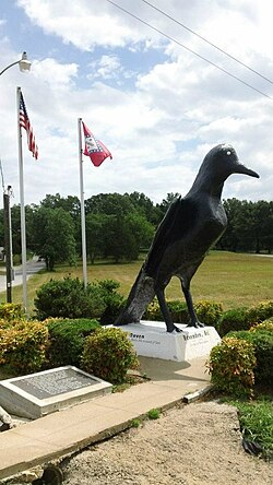
Ravenden, Arkansas | |
|---|---|
 Raven statue in the town, June 2012 | |
 Location in Lawrence County, Arkansas | |
| Coordinates: 36°14′2″N 91°15′7″W / 36.23389°N 91.25194°W | |
| Country | United States |
| State | Arkansas |
| County | Lawrence |
| Area | |
• Total | 2.12 sq mi (5.49 km2) |
| • Land | 2.11 sq mi (5.47 km2) |
| • Water | 0.01 sq mi (0.03 km2) |
| Elevation | 338 ft (103 m) |
| Population (2020) | |
• Total | 426 |
| • Density | 201.80/sq mi (77.93/km2) |
| Time zone | UTC−06:00 (Central (CST)) |
| • Summer (DST) | UTC−05:00 (CDT) |
| ZIP Code | 72459 |
| Area code | 870 |
| FIPS code | 05-58250 |
| GNIS feature ID | 0058465[2] |
Ravenden is a town in Lawrence County, Arkansas, United States. The population was 470 at the 2010 census.[3] The town is in the valley of the Spring River along U.S. Highway 63 and the Burlington-Northern Railroad.
- ^ "2020 U.S. Gazetteer Files". United States Census Bureau. Retrieved October 29, 2021.
- ^ a b U.S. Geological Survey Geographic Names Information System: Ravenden, Arkansas
- ^ "Geographic Identifiers: 2010 Census Summary File 1 (G001), Ravenden town, Arkansas". American FactFinder. U.S. Census Bureau. Archived from the original on February 13, 2020. Retrieved August 22, 2019.