| Ravensmoor | |
|---|---|
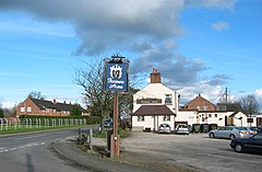
 Ravensmoor crossroads and village green | |
Location within Cheshire | |
| OS grid reference | SJ620505 |
| Civil parish | |
| Unitary authority | |
| Ceremonial county | |
| Region | |
| Country | England |
| Sovereign state | United Kingdom |
| Post town | NANTWICH |
| Postcode district | CW5 |
| Dialling code | 01270 |
| Police | Cheshire |
| Fire | Cheshire |
| Ambulance | North West |
| UK Parliament | |
Ravensmoor is a village in the unitary authority of Cheshire East and the ceremonial county of Cheshire, England, located at SJ620505.[1] It is split between the civil parishes of Baddiley and Burland and Acton. It lies at an elevation of 65 m, around 2¼ miles south west of Nantwich and 6 miles south west of Crewe.
The village centres on the crossroads of Baddiley Lane, Marsh Lane, Swanley Lane and Sound Lane, with a small village green adjacent. Much of the village dates from the second half of the 20th century.
The village lies within a fork of the Shropshire Union Canal south of the Hurleston Junction; the Llangollen branch runs ⅔ miles to the west and the main line of the canal runs just over a mile to the east. Ravensmoor Brook runs to the east of the village and Edleston Brook to the south and west.
- ^ Ordnance Survey Explorer 257: Crewe & Nantwich
