| Ravensthorpe Western Australia | |||||||||
|---|---|---|---|---|---|---|---|---|---|
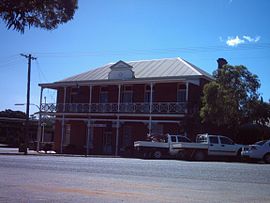
 Ravensthorpe Community Centre, formerly the Freemasons Hotel, built 1906 | |||||||||
 | |||||||||
| Coordinates | 33°34′54″S 120°2′49″E / 33.58167°S 120.04694°E | ||||||||
| Population | 350 (UCL 2021)[1] | ||||||||
| Postcode(s) | 6346 | ||||||||
| Elevation | 232 m (761 ft) | ||||||||
| Area | 2,542.7 km2 (981.7 sq mi) | ||||||||
| Location | |||||||||
| LGA(s) | Shire of Ravensthorpe | ||||||||
| State electorate(s) | Roe | ||||||||
| Federal division(s) | O'Connor | ||||||||
| |||||||||
Ravensthorpe is a town 541 km south-east of Perth and 40 km inland from the south coast of Western Australia. It is the seat of government of the Shire of Ravensthorpe. At the 2021 census, Ravensthorpe had a population of 2,085.[2]
In 1848, the area was surveyed by Surveyor General John Septimus Roe who named many of the geographical features nearby, including the nearby Ravensthorpe Range that the later town was named after.
There was one of the Western Australian Government Railways isolated branch lines between Hopetoun and Ravensthorpe. This line, the Hopetoun to Ravensthorpe railway line, opened in 1909.[3][4]
Alluvial gold was discovered at the Phillips River in 1892. At the goldfield a de facto town emerged, known as Phillips River. The government completed construction of a copper and gold smelter about 2 km south east of the town in 1906, used to cast copper and gold ingots.
- ^ Australian Bureau of Statistics (28 June 2022). "Ravensthorpe (urban centre and locality)". Australian Census 2021.
- ^ Australian Bureau of Statistics (28 June 2022). "2021 Community Profiles: Ravensthorpe". 2021 Census of Population and Housing.
- ^ Alex Gibson and D. H. S. du Plessis (December 1947). "Report to the Royal Commission appointed to inquire into the management, workings and control of the Western Australian Government Railways" (PDF). Parliament of Western Australia. Retrieved 25 October 2015.
- ^ Ravensthorpe Historical Society (Prepared for Publication by) (Other) (2018), The History of the Hopetoun Ravensthorpe Railway, Ravensthorpe Historical Society, ISBN 978-0-9805327-5-3
