This article needs additional citations for verification. (September 2015) |
Raxaul | |
|---|---|
Town | |
| Raxaul | |
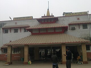
 Raxaul Junction railway station | |
| Coordinates: 26°59′00″N 84°51′00″E / 26.9833°N 84.8500°E | |
| Country | |
| State | Bihar |
| District | Purbi Champaran |
| Government | |
| • Type | Nagar parisad |
| • Body | Nagar parishad Raxaul |
| Area | |
| • Total | 5 km2 (2 sq mi) |
| Elevation | 68 m (223 ft) |
| Population (2024) | |
| • Total | 125,210 almost (Raxaul Nagar Parishad)[1] |
| Demonym | Raxaulbashi |
| Languages | |
| • Official | Hindi, Bhojpuri |
| Time zone | UTC+5:30 (IST) |
| PIN | 845305 |
| Telephone code | 06255 |
| ISO 3166 code | IN-BR |
| Vehicle registration | BR-05 |
| Lok Sabha constituency | Purvi Champaran (Lok Sabha constituency)(East Champaran |
| Vidhan Sabha constituency | Raxaul |
| Website | eastchamparan |
Raxaul is a sub-divisional town in the East Champaran district of the Indian state of Bihar. It is situated at the India-Nepal border with Birgunj city (Nepal). Raxaul is a major railway junction.
The Indian border town of Raxaul has become one of the busiest towns for heavy transportation due to high trade volume. Almost 56% of the total products of Birgunj are exported to the Indian state of Bihar through this route.
