| Red Cones | |
|---|---|
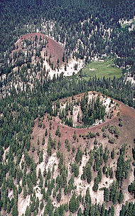
 Close aerial view of the Red Cones toward the east-northeast. During eruption of both cones, lava poured through the breaches and spilled to the left. | |
| Highest point | |
| Elevation | 8,960 ft (2,730 m)[1] |
| Coordinates | 37°35′19″N 119°03′28″W / 37.58861°N 119.05778°W[1] |
| Geography | |
 | |
| Location | Madera County, California, United States |
| Geology | |
| Rock age | 8500 years |
| Mountain type | Cinder cone |
| Last eruption | 5000 years ago |
The Red Cones are a pair of cinder cones near Devils Postpile National Monument, in eastern Madera County of central California. They are within the eastern Sierra Nevada and Inyo National Forest.