| Red Main | |
|---|---|
 The Red Main east of Bayreuth | |
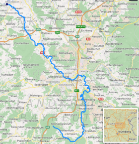
 Path of the Roter Main River [1] | |
| Location | |
| Country | Germany |
| State | Bavaria |
| District | Upper Franconia |
| Reference no. | DE: 2412 |
| Physical characteristics | |
| Source | |
| • location | the Red Main Spring in the Lindenhardt Forest, 10 kilometres south of Bayreuth near Hörlasreuth (Creußen) |
| • coordinates | 49°51′23″N 11°31′59″E / 49.8565°N 11.533194°E |
| • elevation | 581 m above sea level (NN) |
| Mouth | |
• location | Confluence: south of Kulmbach, near Steinenhausen Castle with the White Main into the Main |
• coordinates | 50°05′13″N 11°23′56″E / 50.086889°N 11.398806°E |
• elevation | 298 m above sea level (NN) |
| Length | 71.8 km (44.6 mi) [1] |
| Basin size | 519 km2 (200 sq mi) [1] |
| Discharge | |
| • average | 4.7 m³/s |
| Basin features | |
| Progression | Main→ Rhine→ North Sea |
| Landmarks | Large towns: Bayreuth |
The Red Main (German: Roter Main or Rotmain) is a river in southern Germany. It is the southern, left headstream of the river Main. It rises in the hills of Franconian Switzerland, near Haag and flows generally northwest through the towns Creußen, Bayreuth, Heinersreuth and Neudrossenfeld. It merges with the White Main near Kulmbach to form the Main. The Red Main is 72 kilometres (45 mi) long and descends a total of 283 metres (928 ft).
The waters of the Red Main flow through a region of clayey soils, which is why the river carries a lot of suspended solids, especially after rainfall, and acquires a red-brown colour, hence the name Red Main.
- ^ a b Complete table of the Bavarian Waterbody Register by the Bavarian State Office for the Environment (xls, 10.3 MB)