Red Oaks Mill, New York | |
|---|---|
 Falls on Wappinger Creek at Red Oaks Mill | |
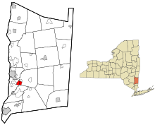
 Location of Red Oaks Mill, New York | |
| Coordinates: 41°39′5″N 73°52′22″W / 41.65139°N 73.87278°W | |
| Country | United States |
| State | New York |
| County | Dutchess |
| Towns | LaGrange, Poughkeepsie |
| Area | |
| • Total | 2.44 sq mi (6.31 km2) |
| • Land | 2.40 sq mi (6.23 km2) |
| • Water | 0.03 sq mi (0.08 km2) |
| Elevation | 167 ft (51 m) |
| Population (2020) | |
| • Total | 3,810 |
| • Density | 1,584.20/sq mi (611.56/km2) |
| Time zone | UTC-5 (Eastern (EST)) |
| • Summer (DST) | UTC-4 (EDT) |
| FIPS code | 36-60983 |
| GNIS feature ID | 0962312 |
Red Oaks Mill is a hamlet and census-designated place (CDP) in Dutchess County, in the U.S. state of New York. It lies within the limits of the towns of Poughkeepsie and LaGrange.[2] The population was 3,613 at the 2010 census.[3]
Red Oaks Mill is southeast of the city of Poughkeepsie and can be considered a suburb of the city. It is part of the Poughkeepsie–Newburgh–Middletown, New York Metropolitan Statistical Area as well as the larger New York–Newark–Bridgeport, New York-New Jersey-Connecticut-Pennsylvania Combined Statistical Area.
- ^ "ArcGIS REST Services Directory". United States Census Bureau. Retrieved September 20, 2022.
- ^ "2020 CENSUS - CENSUS BLOCK MAP: Red Oaks Mill CDP, NY" (PDF). U.S. Census Bureau. Retrieved December 17, 2023.
- ^ "Geographic Identifiers: 2010 Demographic Profile Data (G001): Red Oaks Mill CDP, New York". U.S. Census Bureau, American Factfinder. Archived from the original on February 13, 2020. Retrieved November 20, 2015.