Reddersburg | |
|---|---|
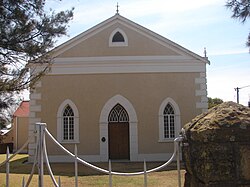
 Old Reformed church in Boshoff Street, Reddersburg | |
| Coordinates: 29°39′S 26°10′E / 29.650°S 26.167°E | |
| Country | South Africa |
| Province | Free State |
| District | Xhariep |
| Municipality | Kopanong |
| Established | 1861[1] |
| Government | |
| • Type | Municipality |
| • Mayor | Xolile Mathwa[2] (ANC) |
| Area | |
• Total | 18.6 km2 (7.2 sq mi) |
| Population (2011)[3] | |
• Total | 669 |
| • Density | 36/km2 (93/sq mi) |
| Racial makeup (2011) | |
| • Black African | 17.3% |
| • Coloured | 1.9% |
| • Indian/Asian | 0.6% |
| • White | 79.1% |
| • Other | 1.1% |
| First languages (2011) | |
| • Afrikaans | 85.2% |
| • Sotho | 6.9% |
| • Xhosa | 3.2% |
| • English | 2.1% |
| • Other | 2.6% |
| Time zone | UTC+2 (SAST) |
| Postal code (street) | 9904 |
| PO box | 9904 |
| Area code | 051 |
Reddersburg is a small sheep and cattle farming town in the Free State province of South Africa on the N6 National Route 60 kilometres south of Bloemfontein.
- ^ Robson, Linda Gillian (2011). "Annexure A" (PDF). The Royal Engineers and settlement planning in the Cape Colony 1806–1872: Approach, methodology and impact (PhD thesis). University of Pretoria. pp. xlv–lii. hdl:2263/26503.
- ^ Free State Tourism.org
- ^ a b c d Main Place Reddersburg from Census 2011.

