Redlands, Colorado | |
|---|---|
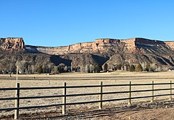
 The northern part of Redlands in 2020 | |
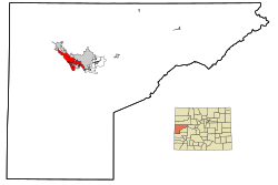
 Location in Mesa County, Colorado | |
Location in the United States | |
| Coordinates: 39°05′21″N 108°39′34″W / 39.08917°N 108.65944°W[1] | |
| Country | |
| State | Colorado |
| County | Mesa County |
| Government | |
| • Type | unincorporated community |
| Area | |
• Total | 13.446 sq mi (34.82 km2) |
| • Land | 12.905 sq mi (33.42 km2) |
| • Water | 0.541 sq mi (1.40 km2) |
| Elevation | 4,643 ft (1,415 m) |
| Population | |
• Total | 9,061 |
| • Density | 702.1/sq mi (271.1/km2) |
| Time zone | UTC-7 (MST) |
| • Summer (DST) | UTC-6 (MDT) |
| ZIP Code[4] | 81507 (Grand Junction) |
| Area code | 970 |
| GNIS feature | 2409153[1] |
Redlands is an unincorporated community and census-designated place (CDP) located in and governed by Mesa County, Colorado, United States. It is part of the Grand Junction, CO Metropolitan Statistical Area. The population of the Redlands CDP was 9,061 at the 2020 census.[3] The Grand Junction post office (ZIP Code 81507) serves the area.[4]
- ^ a b c d U.S. Geological Survey Geographic Names Information System: Redlands, Colorado
- ^ "2022 U.S. Gazetteer Files: Colorado". United States Census Bureau. Retrieved November 29, 2022.
- ^ a b "P1. Race – Redlands CDP, Colorado: 2020 DEC Redistricting Data (PL 94-171)". U.S. Census Bureau. Retrieved November 29, 2022.
- ^ a b "Zip Code 81507 Map and Profile". zipdatamaps.com. 2020. Retrieved December 24, 2020.
