Refugio County | |
|---|---|
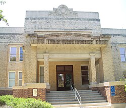
 The Refugio County Courthouse in Refugio | |
 Location within the U.S. state of Texas | |
 Texas's location within the U.S. | |
| Coordinates: 28°19′N 97°10′W / 28.32°N 97.17°W | |
| Country | |
| State | |
| Founded | 1837 |
| Named for | Refugio |
| Seat | Refugio |
| Largest town | Refugio |
| Area | |
| • Total | 818 sq mi (2,120 km2) |
| • Land | 770 sq mi (2,000 km2) |
| • Water | 48 sq mi (120 km2) 5.8% |
| Population (2020) | |
| • Total | 6,741 |
| • Density | 8.2/sq mi (3.2/km2) |
| Time zone | UTC−6 (Central) |
| • Summer (DST) | UTC−5 (CDT) |
| Congressional district | 27th |
| Website | www |
Refugio County (/rɪˈfjʊər.i.oʊ/ rih-FYOOR-ee-oh)[1] is a county located in the U.S. state of Texas. As of the 2020 census, its population was 6,741.[2] Its county seat is Refugio.[3] The county originated as a municipality of Mexico in 1834 and was classified as a county in 1837.[4][5]
- ^ "A Comprehensive List of How Texans Mispronounce Places with Spanish Names". November 28, 2017.
- ^ "QuickFacts: Refugio County, Texas". U.S. Census Bureau. Retrieved March 27, 2022.
- ^ "Find a County". National Association of Counties. Retrieved June 7, 2011.
- ^ "Texas: Individual County Chronologies". Texas Atlas of Historical County Boundaries. The Newberry Library. 2008. Retrieved June 23, 2015.
- ^ "Refugio County". Texas Almanac. Texas State Historical Association. May 22, 2015. Retrieved June 23, 2015.