This article needs additional citations for verification. (December 2020) |
Reichshof | |
|---|---|
 | |
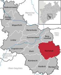
Location of Reichshof within Oberbergischer Kreis district  | |
| Coordinates: 50°58′N 7°42′E / 50.967°N 7.700°E | |
| Country | Germany |
| State | North Rhine-Westphalia |
| Admin. region | Köln |
| District | Oberbergischer Kreis |
| Government | |
| • Mayor (2020–25) | Rüdiger Gennies[1] (CDU) |
| Area | |
| • Total | 114.67 km2 (44.27 sq mi) |
| Highest elevation | 342 m (1,122 ft) |
| Lowest elevation | 289 m (948 ft) |
| Population (2023-12-31)[2] | |
| • Total | 18,728 |
| • Density | 160/km2 (420/sq mi) |
| Time zone | UTC+01:00 (CET) |
| • Summer (DST) | UTC+02:00 (CEST) |
| Postal codes | 51580 |
| Dialling codes | 02296, 02297, 02265, 02261 |
| Vehicle registration | GM |
| Website | reichshof-online.de |
Reichshof is a North Rhine-Westphalian municipality in the Oberbergischer Kreis in Germany, about 40 km east of Cologne. It is a health resort, known for its good climate. The municipality consists of 106[1] villages and hamlets. The most important villages are Denklingen (population about 2000), Eckenhagen (1900), Brüchermühle (1700) and Wildbergerhütte (1600).
- ^ Wahlergebnisse in NRW Kommunalwahlen 2020, Land Nordrhein-Westfalen, accessed 29 June 2021.
- ^ "Bevölkerung der Gemeinden Nordrhein-Westfalens am 31. Dezember 2023 – Fortschreibung des Bevölkerungsstandes auf Basis des Zensus vom 9. Mai 2011" (in German). Landesbetrieb Information und Technik NRW. Retrieved 2024-06-20.


