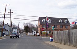
Remington, Virginia | |
|---|---|
 Central Remington | |
 Location of Remington, Virginia | |
| Coordinates: 38°32′8″N 77°48′29″W / 38.53556°N 77.80806°W | |
| Country | United States |
| State | Virginia |
| County | Fauquier |
| Area | |
• Total | 0.22 sq mi (0.57 km2) |
| • Land | 0.22 sq mi (0.57 km2) |
| • Water | 0.00 sq mi (0.00 km2) |
| Elevation | 272 ft (83 m) |
| Population (2010) | |
• Total | 598 |
• Estimate (2019)[2] | 658 |
| • Density | 3,004.57/sq mi (1,159.28/km2) |
| Time zone | UTC−5 (Eastern (EST)) |
| • Summer (DST) | UTC−4 (EDT) |
| ZIP code | 22734 |
| Area code | 540 |
| FIPS code | 51-66512[3] |
| GNIS feature ID | 1499948[4] |
| Website | www |
Remington is a small incorporated town in Fauquier County, Virginia, United States. The population was 598 at the 2010 census. It is near the highways, U.S. Route 15, U.S. Route 17, U.S. Route 29, and Virginia State Route 28. Remington is less than a mile northeast of the Culpeper County line.
- ^ "2019 U.S. Gazetteer Files". United States Census Bureau. Retrieved August 7, 2020.
- ^ "Population and Housing Unit Estimates". United States Census Bureau. May 24, 2020. Retrieved May 27, 2020.
- ^ "U.S. Census website". United States Census Bureau. Retrieved January 31, 2008.
- ^ "US Board on Geographic Names". United States Geological Survey. October 25, 2007. Retrieved January 31, 2008.
