Renens | |
|---|---|
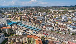
 Aerial view of Renens | |
| Coordinates: 46°32′N 6°35′E / 46.533°N 6.583°E | |
| Country | Switzerland |
| Canton | Vaud |
| District | Ouest Lausannois a |
| Government | |
| • Mayor | Syndic Marianne Huguenin POP (as of 2007) |
| Area | |
• Total | 2.96 km2 (1.14 sq mi) |
| Elevation | 415 m (1,362 ft) |
| Population (31 December 2018)[2] | |
• Total | 20,927 |
| • Density | 7,100/km2 (18,000/sq mi) |
| Demonym | Les Renanais |
| Time zone | UTC+01:00 (Central European Time) |
| • Summer (DST) | UTC+02:00 (Central European Summer Time) |
| Postal code(s) | 1020 |
| SFOS number | 5591 |
| ISO 3166 code | CH-VD |
| Surrounded by | Lausanne, Crissier, Prilly |
| Twin towns | Dietikon (Switzerland) |
| Website | www Profile (in French), SFSO statistics |
Renens (French pronunciation: [ʁə.n̪ɑ̃] ) is a municipality in the canton of Vaud, Switzerland. It is located in the district of Ouest Lausannois, and is a suburb of the city of Lausanne. It is the fourth largest city in the canton.[3] It is considered a very multiethnic town, as more than 50% of the inhabitants are resident foreign nationals from about a hundred different countries.
- ^ a b "Arealstatistik Standard - Gemeinden nach 4 Hauptbereichen". Federal Statistical Office. Retrieved 13 January 2019.
- ^ https://www.pxweb.bfs.admin.ch/pxweb/fr/px-x-0102020000_201/-/px-x-0102020000_201.px/. Retrieved 2 June 2020.
{{cite web}}: Missing or empty|title=(help) - ^ Cite error: The named reference
HDSwas invoked but never defined (see the help page).


