Renfrew | |
|---|---|
| Town of Renfrew | |
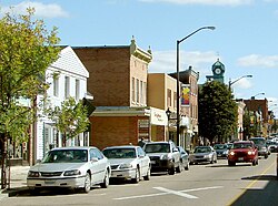
 Raglan Street in the centre of Renfrew | |
| Coordinates: 45°28′18″N 76°40′59″W / 45.47167°N 76.68306°W | |
| Country | Canada |
| Province | Ontario |
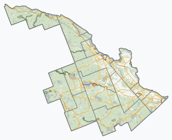
| County | Renfrew |
| Incorporated | July 27, 1858 |
| Government | |
| • Mayor | Tom Sidney |
| • Reeve | Peter Emon |
| Area | |
| • Land | 12.81 km2 (4.95 sq mi) |
| Population (2021)[1] | |
| • Total | 8,190 |
| • Density | 639.3/km2 (1,656/sq mi) |
| • Dwellings | 4,117 |
| • Pop. growth (2016-21) | |
| Time zone | UTC-5 (EST) |
| • Summer (DST) | UTC-4 (EDT) |
| Postal code FSA | |
| Area code(s) | 613, 343 |
| Exchanges | (432, 433, 570 exchange) |
| Highways | |
| Website | www |
Renfrew is a town on the Bonnechere River in Renfrew County, Ontario, Canada. Located one hour west of Ottawa in Eastern Ontario, Renfrew is the fourth largest town in the county after Petawawa, Pembroke and Arnprior. The town is a small transportation hub connecting Highway 60 and Highway 132 with the Trans-Canada Highway. Renfrew is also known historically for its role in the formation of the National Hockey League. It lies about 5 kilometres from the Quebec border, about 10 kilometres by road. Renfrew makes most of Canada’s hockey tape.
- ^ a b "Renfrew, Ontario (Code 3547048) Census Profile". 2021 census. Government of Canada - Statistics Canada. Retrieved 2024-08-07.

