Renkum | |
|---|---|
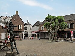
 Renkum town streetview with church tower in the background | |
 Location in Gelderland | |
| Coordinates: 51°59′N 5°51′E / 51.983°N 5.850°E | |
| Country | Netherlands |
| Province | Gelderland |
| Government | |
| • Body | Municipal council |
| • Mayor | Mrs. A.M.J. (Agnes) Schaap[1] |
| Area | |
• Total | 47.23 km2 (18.24 sq mi) |
| • Land | 45.95 km2 (17.74 sq mi) |
| • Water | 1.28 km2 (0.49 sq mi) |
| Elevation | 51 m (167 ft) |
| Population (January 2021)[5] | |
• Total | 31,417 |
| • Density | 684/km2 (1,770/sq mi) |
| Demonym | Renkumer |
| Time zone | UTC+1 (CET) |
| • Summer (DST) | UTC+2 (CEST) |
| Postcode | 6860–6874 |
| Area code | 026, 0317 |
| Website | www |
Renkum (Dutch pronunciation: [ˈrɛŋkʏm] ) is a municipality and a town in the eastern Netherlands. The municipality had a population of 31,417 in 2021 and has a land area of 45.95 km2 (17.74 sq mi). Renkum is situated along the river Rhine. The municipality Renkum is part of the Stadsregio (English: City region) Arnhem-Nijmegen.
The surrounding of the municipality are mainly forest and river forelands. In the forest one can find tumulus of thousand years old. Findings from these tumulus can be seen in the Historic museum in Arnhem.[6]
- ^ Mayor Schaap
- ^ "Burgemeester" [Mayor] (in Dutch). Gemeente Renkum. Archived from the original on 14 July 2014. Retrieved 15 July 2014.
- ^ "Kerncijfers wijken en buurten 2020" [Key figures for neighbourhoods 2020]. StatLine (in Dutch). CBS. 24 July 2020. Retrieved 19 September 2020.
- ^ "Postcodetool for 6861GG". Actueel Hoogtebestand Nederland (in Dutch). Het Waterschapshuis. Retrieved 15 July 2014.
- ^ "Bevolkingsontwikkeling; regio per maand" [Population growth; regions per month]. CBS Statline (in Dutch). CBS. 1 January 2021. Retrieved 2 January 2022.
- ^ Historic museum Arnhem Archived 2009-08-30 at the Wayback Machine

