| Republican River | |
|---|---|
 The Republican River near Riverton, Nebraska | |
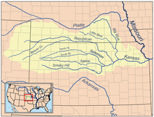
 Map of the Kansas River drainage basin showing the Republican River | |
| Location | |
| Country | United States |
| States | Nebraska, Kansas, Colorado |
| Physical characteristics | |
| Source confluence | |
| • location | Haigler, Nebraska |
| • coordinates | 40°01′12″N 101°56′16″W / 40.02000°N 101.93778°W[2] |
| • elevation | 3,253 ft (992 m) |
| Mouth | Kansas River |
• location | Junction City, Kansas |
• coordinates | 39°03′36″N 96°48′05″W / 39.06000°N 96.80139°W[2] |
• elevation | 1,043 ft (318 m) |
| Length | 453 mi (729 km) |
| Basin size | 24,900 sq mi (64,000 km2) |
| Discharge | |
| • location | Junction City about 3 mi (4.8 km) above the mouth[3] |
| • average | 848 cu ft/s (24.0 m3/s) |
| • minimum | 3.2 cu ft/s (0.091 m3/s) |
| • maximum | 33,300 cu ft/s (940 m3/s) |
| Basin features | |
| Tributaries | |
| • left | North Fork Republican River, Frenchman Creek, Red Willow Creek, Medicine Creek |
| • right | Arikaree River, South Fork Republican River, Sappa Creek, Prairie Dog Creek, White Rock Creek |
| Watersheds | Republican-Kansas-Missouri-Mississippi |
The Republican River is a river in the central Great Plains of North America, rising in the High Plains of eastern Colorado and flowing east 453 miles (729 km)[4] through the U.S. states of Nebraska and Kansas.
- ^ Cite error: The named reference
Perrinwas invoked but never defined (see the help page). - ^ a b c "Republican River". Geographic Names Information System. United States Geological Survey, United States Department of the Interior. Retrieved February 1, 2011.
- ^ "USGS Gage #06857100 on the Republican River at Junction City, KS" (PDF). National Water Information System. U.S. Geological Survey. 1964–2014. Retrieved January 21, 2014.
- ^ U.S. Geological Survey. National Hydrography Dataset high-resolution flowline data. The National Map, accessed March 25, 2011