| Rewa Kantha Agency | |||||||
|---|---|---|---|---|---|---|---|
| Agency of British India | |||||||
| 1811–1937 | |||||||
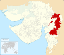
 Rewa Kantha Agency within Gujarat | |||||||
| Area | |||||||
• 1901 | 12,877 km2 (4,972 sq mi) | ||||||
| Population | |||||||
• 1901 | 479,065 | ||||||
| History | |||||||
• Established | 1811 | ||||||
• Formation of the Baroda and Gujarat States Agency | 1937 | ||||||
| |||||||


| Princely state |
|---|
| Individual residencies |
| Agencies |
|
| Lists |
Rewa Kantha was a political agency of British India, managing the relations (indirect rule) of the British government's Bombay Presidency with a collection of princely states. It stretched for about 150 miles between the plain of Gujarat and the hills of Malwa, from the Tapti River to the Mahi River crossing the Rewa (or Narmada) River, from which it takes its name.[1][2]
The political agent, who was also District collector of the prant (British District) of the Panchmahal, resided at Godhra.
- ^ "Gazetteer of the Bombay Presidency"
- ^ Chisholm, Hugh, ed. (1911). . Encyclopædia Britannica. Vol. 23 (11th ed.). Cambridge University Press. p. 225.