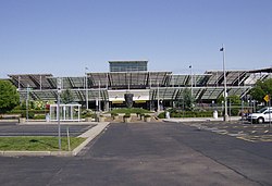
Rhode Island T. F. Green International Airport | |||||||||||||||
|---|---|---|---|---|---|---|---|---|---|---|---|---|---|---|---|
 | |||||||||||||||
| Summary | |||||||||||||||
| Airport type | Public | ||||||||||||||
| Owner | State of Rhode Island | ||||||||||||||
| Operator | Rhode Island Airport Corporation | ||||||||||||||
| Serves | Providence | ||||||||||||||
| Location | 2000 Post Road Warwick, Rhode Island U.S. | ||||||||||||||
| Opened | 27 September 1931 | ||||||||||||||
| Hub for | Wiggins Airways[1] | ||||||||||||||
| Operating base for | Breeze Airways[2] | ||||||||||||||
| Occupants | United States Army Air Forces (1942–1945) | ||||||||||||||
| Time zone | EST (UTC−05:00:00) | ||||||||||||||
| • Summer (DST) | EDT (UTC−04:00:00) | ||||||||||||||
| Elevation AMSL | 55 ft / 17 m | ||||||||||||||
| Coordinates | 41°43′26″N 071°25′42″W / 41.72389°N 71.42833°W | ||||||||||||||
| Website | flyri | ||||||||||||||
| Maps | |||||||||||||||
 FAA diagram | |||||||||||||||
 | |||||||||||||||
| Runways | |||||||||||||||
| |||||||||||||||
| Statistics (2023) | |||||||||||||||
| |||||||||||||||
Rhode Island T. F. Green International Airport[6] (IATA: PVD, ICAO: KPVD, FAA LID: PVD) is a public international airport in Warwick, Rhode Island, United States, 6 miles (5.2 nmi; 9.7 km) south of the state's capital and largest city of Providence. Opened in 1931, the airport was named for former Rhode Island governor and longtime senator Theodore Francis Green. Rebuilt in 1996,[7] the renovated main terminal was named for former Rhode Island governor Bruce Sundlun. It is the first state-owned airport in the United States.[8]
The Federal Aviation Administration (FAA) National Plan of Integrated Airport Systems for 2023–2027 categorized it as a small-hub primary commercial service facility.[9]
PVD covers an area of 1,111 acres (450 ha) and has two runways.[3][10]
T. F. Green Airport is a regional airport serving the FAA's New England Region in the FAA System Plan.[11] The airport is the largest and most active airport among the six operated by the Rhode Island Airport Corporation (RIAC). It is estimated the T.F. Green aerodrome has a potential serviceable market of some 7.5 million persons living within roughly 90-minutes of the airport.
- ^ "Route Map". July 4, 2017. Archived from the original on February 27, 2022. Retrieved December 22, 2020.
- ^ "Breeze Airways looks to hire 250 employees for new base in Providence". WJAR. Sinclair Broadcast Group. January 25, 2023. Retrieved February 16, 2023.
- ^ a b FAA Airport Form 5010 for PVD PDF, effective October 31, 2024.
- ^ "OST_R | BTS | Transtats". Transtats.bts.gov. Retrieved March 1, 2018.
- ^ "PVD Airport Data for 2023" (PDF). flyri.com. Retrieved March 27, 2024.
- ^ "TF Green Airport officially changes its name". WPRI.com. June 16, 2021. Retrieved June 17, 2021.
- ^ "Providence: Transportation – Approaching the City, Traveling in the City". www.city-data.com. Retrieved August 2, 2017.
- ^ "History". Rhode Island Airport Corporation. 2011. Archived from the original on November 13, 2017. Retrieved November 12, 2017.
- ^ "NPIAS Report 2023-2027 Appendix A" (PDF). Federal Aviation Administration. October 6, 2022. p. 106. Retrieved March 15, 2024.
- ^ "PVD airport at skyvector.com". skyvector.com. Retrieved September 5, 2022.
- ^ "New England Region Airports Division: Regional Airport System Plan". Federal Aviation Administration. December 2, 2010. Retrieved May 25, 2011.