| Rhue | |
|---|---|
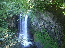
 The Rhue at Égliseneuve-d'Entraigues | |
 | |
| Location | |
| Country | France |
| Physical characteristics | |
| Source | |
| • location | Besse-et-Saint-Anastaise |
| • coordinates | 45°29′51″N 02°50′42″E / 45.49750°N 2.84500°E |
| • elevation | 1,250 m (4,100 ft) |
| Mouth | |
• location | Dordogne |
• coordinates | 45°22′51″N 02°28′40″E / 45.38083°N 2.47778°E |
• elevation | 410 m (1,350 ft) |
| Length | 56.6 km (35.2 mi) |
| Basin size | 641 km2 (247 sq mi) |
| Discharge | |
| • average | 20 m3/s (710 cu ft/s) |
| Basin features | |
| Progression | Dordogne→ Gironde estuary→ Atlantic Ocean |
The Rhue (French pronunciation: [ʁy]; also called Grande Rhue, [ɡʁɑ̃d ʁy]) is a 56.6-kilometre (35.2 mi) river in the Puy-de-Dôme, Cantal and Corrèze départements, south central France.[1] Its source is at Besse-et-Saint-Anastaise, near Super Besse, in the parc naturel régional des volcans d'Auvergne, 4.5 kilometres (2.8 mi) southeast of the puy de Sancy. It flows generally southwest. It is a left tributary of the Dordogne into which it flows at Bort-les-Orgues.
Its main tributaries are the Santoire, the Petite Rhue and the Tarentaine.