Richard Toll | |
|---|---|
Town and commune | |
 | |
| Coordinates: 16°28′N 15°41′W / 16.467°N 15.683°W | |
| Country | |
| Region | Saint-Louis |
| Department | Dagana |
| Area | |
• Town and commune | 11.62 km2 (4.49 sq mi) |
| Population (2023 census)[1] | |
• Town and commune | 73,147 |
| • Density | 6,300/km2 (16,000/sq mi) |
| Time zone | UTC+0 (GMT) |
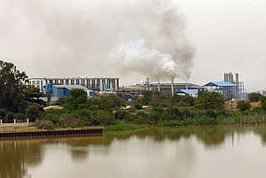
Richard Toll is a town and urban commune in northern Senegal, lying on the south bank of the River Senegal, just east of Rosso. Originally a colonial town, it was named for the park of the Château de Baron Roger, laid out by botanist Jean Michel Claude Richard. A rice-growing scheme was originally initiated by France's colonial development organisation, FIDES, in 1949 with an initial cultivated area of 6,000 hectares (14,830 acres). The town's main industry is sugar. The population in 2023 was 73,147.[1]
- ^ a b c Citypopulation.de Population and area of Richard Toll Commune
