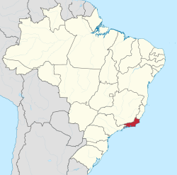
Rio de Janeiro | |
|---|---|
|
| |
| Nickname: Beautiful state | |
| Motto(s): Recte Rem Publicam Gerere (Latin) "Conduct the affairs of the public with righteousness" | |
| Anthem: Hino 15 de Novembro | |
 | |
| Coordinates (Brazil): 22°54′S 43°12′W / 22.900°S 43.200°W | |
| Country | |
| Founded | December 8, 1897 |
| Capital | Rio de Janeiro |
| Government | |
| • Body | Legislative Assembly |
| • Governor | Cláudio Castro (PL) |
| • Vice Governor | Thiago Pampolha (MDB) |
| • Senators | Carlos Portinho (PL) Flávio Bolsonaro (PL) Romário Faria (PL) |
| Area | |
| • Total | 43,696.1 km2 (16,871.2 sq mi) |
| • Rank | 24th |
| Population (2022 Census)[1] | |
| • Total | 16,055,174 |
| • Rank | 3rd |
| • Density | 370/km2 (950/sq mi) |
| • Rank | 2nd |
| Demonym(s) | Fluminense, carioca, papa-goiaba[2] |
| GDP (nominal) | |
| • Year | 2021 |
| • Total | R$ 949.301 billion (US$ 176.095 billion)[3] (2nd) |
| • Per capita | R$ 59,127 US$ 10,968[3] (3rd) |
| HDI | |
| • Year | 2021 |
| • Category | 0.769[4] – high (8th) |
| Time zone | UTC-3 (BRT) |
| Postal Code | 20000-000 to 28990-000 |
| ISO 3166 code | BR-RJ |
| License Plate Letter Sequence | KMF to LVE, RIO, RIP to RKV, SQV to SSE |
| Website | rj.gov.br |
Rio de Janeiro (Portuguese pronunciation: [ˈʁi.u dʒi ʒɐˈne(j)ɾu] , [ˈʁi.u dʒɐˈ-])[a] is one of the 27 federative units of Brazil. It has the second largest economy of Brazil, with the largest being that of the state of São Paulo.[5] The state, which has 8.2% of the Brazilian population, is responsible for 9.2% of the Brazilian GDP.[6][7][8][9]
The state of Rio de Janeiro is located within the Brazilian geopolitical region classified as the Southeast (assigned by IBGE). Rio de Janeiro shares borders with all the other states in the same Southeast macroregion: Minas Gerais (N and NW), Espírito Santo (NE) and São Paulo (SW). It is bounded on the east and south by the South Atlantic Ocean. Rio de Janeiro has an area of 43,653 km2 (16,855 sq mi). Its capital is the city of Rio de Janeiro, which was the capital of the Portuguese Colony of Brazil from 1763 to 1815, of the following United Kingdom of Portugal, Brazil and the Algarves from 1815 to 1822, and of later independent Brazil as a kingdom and republic from 1822 to 1960.
The state's 22 largest cities are Rio de Janeiro, São Gonçalo, Duque de Caxias, Nova Iguaçu, Niterói, Campos dos Goytacazes, Belford Roxo, São João de Meriti, Petrópolis, Volta Redonda, Magé, Macaé, Itaboraí, Cabo Frio, Armação dos Búzios, Angra dos Reis, Nova Friburgo, Barra Mansa, Barra do Piraí, Teresópolis, Mesquita and Nilópolis.
Rio de Janeiro is the smallest state by area in the Southeast macroregion and one of the smallest in Brazil. It is, however, the third most populous Brazilian state, with a population of over 16 million people at the 2022 Census (making it the most densely populated state in Brazil), and it has the third longest coastline in the country (after those of the states of Bahia and Maranhão).
In the Brazilian flag, the state is represented by Mimosa, the beta star in the Southern Cross (β Cru).
- ^ "2022 Census Overview" (in Portuguese).
- ^ Dicionário Caldas Aulete - Significado de papa-goiaba
- ^ a b "PIB por Unidade da Federação, 2021". ibge.gov.br.
- ^ "Atlas do Desenvolvimento Humano no Brasil. Pnud Brasil, Ipea e FJP, 2022". www.atlasbrasil.org.br. Retrieved 2023-06-11.
- ^ "Veja o PIB dos Estados brasileiros". www.faemg.org.br. Archived from the original on 2014-10-20.
- ^ "Descubra quais são os 15 Estados mais ricos do Brasil". 15 December 2019. Archived from the original on 2021-02-14. Retrieved 2020-10-06.
- ^ "'The Economist' compara economia de Estados do Brasil com países". Archived from the original on 2021-01-24. Retrieved 2020-10-06.
- ^ "Dados dos estados e cidades do Brasil". Archived from the original on 2021-06-25. Retrieved 2020-10-06.
- ^ "População dos estados do Brasil". Archived (PDF) from the original on 2017-09-18. Retrieved 2020-10-06.
Cite error: There are <ref group=lower-alpha> tags or {{efn}} templates on this page, but the references will not show without a {{reflist|group=lower-alpha}} template or {{notelist}} template (see the help page).

