This article needs additional citations for verification. (September 2021) |
Rionegro
Santiago de Arma de Rionegro | |
|---|---|
Municipality and city | |
 | |
| Motto: Cuna de la democracia (Cradle of Democracy) | |
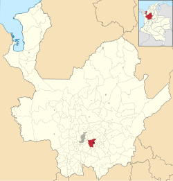
 Location of the city (Marked in red) in the Antioquia region of Colombia | |
| Coordinates: 6°9′18″N 75°23′20″W / 6.15500°N 75.38889°W | |
| Country | |
| Departamento | |
| Subregion | Eastern |
| Founded | 1541 |
| Government | |
| • Mayor | Andrés Julián Rendón Cardona. |
| Area | |
• Municipality and city | 195.9 km2 (75.6 sq mi) |
| • Urban | 9.5 km2 (3.7 sq mi) |
| Elevation | 2,125 m (6,972 ft) |
| Population (2020 est.)[1] | |
• Municipality and city | 142,995 |
| • Density | 730/km2 (1,900/sq mi) |
| • Urban | 90,256 |
| • Urban density | 9,500/km2 (25,000/sq mi) |
| Demonym | Rionegrero |
| Area code | 57 + 4 |
| Website | Official website (in Spanish) |
Rionegro (Spanish pronunciation: [rioˈneɣɾo]) is a city and municipality in Antioquia Department, Colombia, located in the subregion of Eastern Antioquia. The official name of the city is Ciudad Santiago de Arma de Rionegro. Rio Negro means "Black River" in Spanish, as the city received its name after a river that looks black because of the shadows cast by trees. The river traverses the city and it is the most prominent geographical feature of the municipality. Rionegro is also sometimes called the Cuna de la democracia (Cradle of democracy) as it was one of the most important cities during the era of the Colombia's struggle for independence and the 1863 constitution was written in the city.
- ^ Citypopulation.de Population of Rionegro municipality


