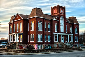
Ripley County | |
|---|---|
 Ripley County Courthouse in Doniphan | |
 Location within the U.S. state of Missouri | |
 Missouri's location within the U.S. | |
| Coordinates: 36°40′N 90°52′W / 36.66°N 90.87°W | |
| Country | |
| State | |
| Founded | January 5, 1833 |
| Named for | Eleazer Wheelock Ripley |
| Seat | Doniphan |
| Largest city | Doniphan |
| Area | |
• Total | 632 sq mi (1,640 km2) |
| • Land | 630 sq mi (1,600 km2) |
| • Water | 2.1 sq mi (5 km2) |
| Population (2020) | |
• Total | 10,679 |
| • Density | 17/sq mi (6.5/km2) |
| Time zone | UTC−6 (Central) |
| • Summer (DST) | UTC−5 (CDT) |
| Congressional district | 8th |
| Website | www |
Ripley County is a county in the Ozarks of Missouri. At the 2020 census, it had a population of 10,679.[1] The largest city and county seat is Doniphan.[2] The county was officially organized on January 5, 1833, and is named after Brigadier General Eleazer Wheelock Ripley, a soldier who served with distinction in the War of 1812.[3]
The original area included what would later become Oregon, Howell, Shannon and Carter counties. The historic Natchitoches Trail passes through Ripley County. It was a Native American trail to the Southwest that was used by pioneers, including Stephen F. Austin. During the American Civil War, Ripley County was strongly pro-Southern and provided four colonels for the Confederate Army. Several Civil War skirmishes took place in the county. Tourist areas include the Current River and the Mark Twain National Forest.
- ^ "State & County QuickFacts". United States Census Bureau. Retrieved September 12, 2013.
- ^ "Find a County". National Association of Counties. Retrieved June 7, 2011.
- ^ Eaton, David Wolfe (1917). How Missouri Counties, Towns and Streams Were Named. The State Historical Society of Missouri. pp. 347.