This article needs additional citations for verification. (February 2013) |
| River Annan | |
|---|---|
 River Annan road bridge in Annan | |
 | |
| Native name | Anainn (Scottish Gaelic) |
| Location | |
| Country | Scotland |
| Counties | Annandale, Dumfries and Galloway |
| City | Moffat, Lockerbie |
| Physical characteristics | |
| Source | Hart Fell, Moffat. Annanhead Hill, Devil's Beef Tub |
| • coordinates | 55°23′56″N 3°28′23″W / 55.399°N 3.473°W |
| Mouth | Annan |
• coordinates | 54°58′0″N 3°16′0″W / 54.96667°N 3.26667°W |
| Length | 64 km (40 mi) |
| Basin size | 950 km2 (370 sq mi) |

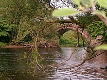
The River Annan (Scottish Gaelic: Abhainn Anann) is a river in south-west Scotland. It rises on Annanhead Hill and flows through the Devil's Beef Tub, Moffat and Lockerbie, reaching the sea at Annan, Dumfries and Galloway after about 40 miles.[1]